First venture offshore to dive california's offshore oil and gas platforms

From Malaysia to the Gulf of Mexico, the Blue Latitudes Foundation (BLF) has explored offshore oil and gas (O&G) platforms around the world. This trip, however, was a little closer to home. In September 2021, the BLF assembled a crew with varied backgrounds in science, art, and underwater videography to dive the offshore O&G platforms in California. For me, it was an especially exciting day, as this trip would mark my very first oil platform dive- an experience I had been looking forward to since starting my position as BLF’s Program Coordinator.

BLF Program Coordinator Jacqueline Rosa ready for her first oil platform dive.

On a quiet morning in San Pedro, we gathered to load the dive boat with gear, tanks, and our Deep Trekker DTG3 remotely operated vehicle (ROV). Captain Jim Simmerman slowly cruised out of Los Angeles Harbor, then headed South towards the Beta Oil Field, an area that includes Platforms Ellen, Elly, Eureka, and Edith. While underway, divers assembled gear, reviewed dive plans, and readied the camera equipment.

Aboard the Giant Stride: (from left to right) Jacqueline Rosa (BLF), Conner Jainese (University of California Santa Barbara), Katelin Seeto (University of California Santa Barbara), Grace Young (Google X), Amber Sparks (BLF), Ami Everett (Blue Latitudes, LLC), and Jacqueline Lehr (Underwater Camera Operator).

Platforms Ellen and Elly – connected by a catwalk above the water- served as our first dive site. Installed in 1980, both platforms are situated in about 260 feet (ft.) of water and are located approximately 9 miles from Huntington Beach, CA. Platform Elly processes production from Platforms Ellen and Eureka, both drilling platforms, and provides water and electricity to each.

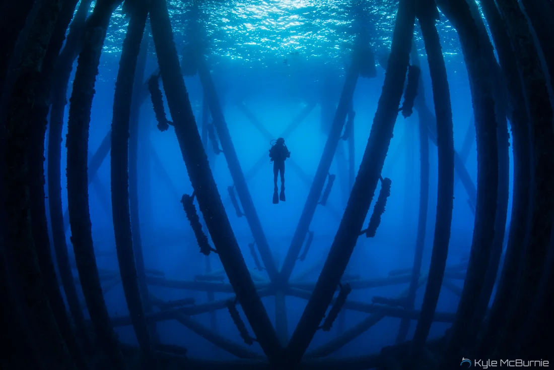
 Captain Jim idled alongside Platform Elly as divers stepped into the water, two by two. Kicking through the strong surface current, my dive buddy and I reached the corner piling of the platform to use as a guide for our descent. As we descended, a group of curious sea lions circled us, and schools of kelp bass and blacksmith swam overhead. While towards the surface we saw a steel giant, the moment we dove in we were met with a vibrant community of fish and invertebrates. Composed of steel beams, the platform structure was encrusted with an array of marine organisms, including bright pink anemones, blue mussels, and countless brittle stars. Once we arrived at the first crossbeam, located at 40 ft., we swam through the complex structure and observed garibaldi and sheephead. From this position under the platform, crossbeams and pylons reached out in every direction, reminding me of how these structures earned the nickname ‘steel giants’.  

Back on the dive boat for a surface interval, we exchanged stories and warmed up while transiting to Platform Eureka, our second dive site. Standing tall in 700 ft. of water, Eureka is the deepest platform accessible to recreational divers in California. While offshore conditions were rough earlier in the day, the wind and current had since calmed, providing an opportunity to launch our DTG3 ROV.  Capable of exploring depths up to 656 ft, the DTG3 ROV is a 19 lb. underwater robot with a high-definition camera and built-in lights. Operated by Amber Sparks, BLF co-president, and Ami Everett, Marine Scientist of Blue Latitudes, LLC, the DTG3 followed divers as they descended into the blue. My dive buddies and I watched the small underwater robot survey Eureka’s shallowest crossbeam at 50 ft. Other divers harvested scallops growing on the pylons, as schools of fish gathered below to collect the scraps. While some species, such as rockfish, utilize O&G platforms as juveniles then move into deeper water, other species find permanent homes along the steel beams.


The Deep Trekker DTG3 remotely operated vehicle (ROV) ready for deployment.

BLF Co-President, Amber Sparks, and Marine Scientist, Ami Everett, take a selfie with Platform Eureka.

As we ascended to the surface, we were once again visited by a group of inquisitive sea lions. My first platform dive trip was in the books, and it did not disappoint. A closer look at life below O&G platforms provided a deepened understanding of how these complex structures support unique communities of marine life.


1% Can Make a Big Impact

The Blue Latitudes Foundation has joined 1% for the Planet as a nonprofit partner! This partnership will not only advance our impact in the ocean conservation space but will also allow us to connect with businesses and individuals who have pledged to give 1% of their sales back to the planet each year – 1% can make a big impact!

 Founded in 2002, 1% for the Planet’s mission is to increase the amount of charitable giving directed towards environmental causes. We’ll be joining this elite network of nonprofits and gain access to a global organization which exists to ensure our planet and future generations thrive by connecting businesses and individuals who pledge to give 1% of their sales back to the planet each year with environmental nonprofits around the world. Currently, in the United States only 3% of total philanthropy goes to environmental causes. On top of that, government funding allocated to the environment is variable even in the best of times.  

 “The intent of 1% for the Planet is to help fund diverse environmental organizations so that collectively they can be a more powerful source in solving the world’s problems,”

 - Yvon Chouinard, co-founder of 1% for the Planet

 The Blue Latitudes Foundation joins a community of 4,878 non-profit partners from 91 countries around the world. As we transition into 2022, we hope that this partnership will help us to broaden the reach of our mission and further our ocean conservation efforts. To join the movement and support our planet, visit 1% for the Planet’s website to learn about business and individual memberships. When we all work together, 1% can make a difference! 

Diving Into the Open Ocean

Open Water Deployment #1 - Huntington Beach

After several months of preparation in protected waters, the Blue Latitudes Foundation (BLF) team recently completed two open ocean deployments with the Deep Trekker DTG3 Remotely Operated Vehicle (ROV)! Fueled by the launch of the BLF’s recent project, an ROV- based community science assessment, our purpose was to test our ROV protocols in the open ocean with the hopes of soon deploying these protocols to gather marine life data on artificial reefs and offshore oil platforms.

A new partnership with the International SeaKeepers Society helped to make our first open ocean voyage possible. SeaKeepers is a non-profit organization that supports marine science and conservation by utilizing privately owned yachts as platforms for research and education. Their DISCOVERY Yacht Program presents opportunities for scientists and educators to eliminate vessel costs and promote community engagement. Through our partnership, the BLF was connected with a yacht owner based in Huntington Beach who was willing to facilitate an expedition aboard his vessel – the Cabrillo.

Aboard the Cabrillo, our team motored out to nearby artificial reefs constructed by California Department of Fish and Wildlife off of the Huntington Beach harbor. We visited four artificial reef sites, each consisting of 1,000 tons of quarry rock. The DTG3 ROV was deployed adjacent to the reefs and dove to approximately 50 feet. While poor visibility and strong currents made it difficult to capture the reefs on camera, our team practiced piloting the underwater drone and performing transects along predetermined compass headings.

IMG_2985.jpg

Aboard the Cabrillo

As we drove to the next location, the captain made a quick stop at Platform Emmy. Built in 1963, this oil platform stands in 83 feet of water and is one of the most productive platforms in California. While gazing up at this massive steel structure, our team was reminded of the thriving ecosystems that exist below the surface.

IMG_2974.jpg

The Blue Latitudes Foundation Team with Platform Emmy

Our next stop was the Long Beach Breakwater. Anchored alongside the breakwater, we launched a new instrument: the Nortek Eco. The Eco is an Acoustic Doppler Current Profiler (ADCP) that measures the movement of water using sound. While tracking ocean currents, this instrument also collects temperature and water pressure data. Understanding currents is important in marine ecosystems because they redistribute heat, nutrients, and oxygen within the ocean. While collecting data, the Eco rests on seafloor and profiles the currents above it. When the timer is up, the Eco self- releases and floats to the surface for retrieval. Portable and practical, we so enjoyed using this ADCP to add additional metrics to our data collection.

 Open Water Deployment #2 - La Jolla Shores

Our second open ocean deployment took place in La Jolla, California. Given the presence of several unique habitats near shore, including sandy bottom, eelgrass beds, and shallow water rocky reef, we opted to launch from kayaks. Calm seas set the stage and after loading up our snorkel gear and scientific instruments, we paddled west off La Jolla shores into about 30 feet of water over a sandy bottom habitat. At this location we released the Eco for a planned deployment of approximately an hour and a half, during which time the Eco collected data while we set off to deploy the DTG3 ROV at the nearby eelgrass beds.

Picture3.jpg

Emily and Amber launching the Deep Trekker DTG3 ROV

Next, we set out to explore the eelgrass beds within the Matlahuayl State Marine Reserve, named in honor of the Kumeyaay tribe that originally inhabited San Diego. A marine reserve is a designated area managed for long-term conservation, that protects crucial habitats and threatened species from harmful human activity (such as overfishing). Because this area of coastline is protected, it is teeming with life! From the surface, we spotted numerous fish and surveyed healthy areas of reef habitat through the lens of the DTG3 ROV. After reeling in the ROV, we paddled back to retrieve the Eco before heading to shore.

 Looking Forward

As our ambassadorship with Deep Trekker comes to a close, the BLF will soon be purchasing a DTG3 ROV of our own. We will continue to pilot test the Nortek Eco and can’t wait for our next expedition in the ocean.

The ROV Adventures Begin

By: Jacqueline Rosa

In preparation for launching a remotely operated vehicle (ROV)-based community science assessment, the Blue Latitudes Foundation (BLF) has spent the past few months pilot testing and learning how to operate Deep Trekker’s DTG3 ROV . Complete with a 50-meter tether and weighing just under 19 lbs., this portable, commercial-grade ROV is an incredible tool for underwater exploration. BLF’s community science program will incorporate volunteer scientists and ROVs to assess the health and productivity of California reef habitat.  

The first phase of DTG3 pilot tests took place in the controlled environment of our neighborhood pool, where calm water conditions and visibility allowed us to keep a close eye on the ROV. Achieving neutral buoyancy was the first objective when placing the DTG3 into water. Because bodies of water can have varying densities depending on their salinity levels, the weight, or ‘ballast’ of the ROV needed to be adjusted accordingly. A neutrally buoyant ROV will maintain its sampling depth, neither sinking nor floating to the surface. The DTG3 model includes small weights that can be added or subtracted to adjust the overall weight. After a few rounds of trial and error, our team successfully balanced the DTG3. Next, we tested driving the ROV at various speeds and determined an ideal sampling speed (1 meter/ second) that would allow for careful observation. As the DTG3 cruised around the pool, we engaged the internal LED floodlights and experimented with capturing underwater photos and videos. A handy ‘camera lock’ function allows the driver to lock the camera angle during use, keeping the bottom in view.

From the view of the ROV camera… the BLF team at their first pool dive!

From the view of the ROV camera… the BLF team at their first pool dive!

The next stop for our pilot tests was Mission Bay, located in San Diego, California. This setting presented new challenges for the DTG3, including saltwater, tides, and currents. Because objects in saltwater are more buoyant than objects in freshwater, additional weights were added to the DTG3 before launching into Mission Bay. Once in the water, the sandy bottom and bright green eelgrass came into view. We quickly noted an outgoing tide was impacting ROV maneuverability. To combat this current, the speed and steering settings were adjusted to give the driver better control.

Setting up the DTG3 ROV for a dive in Mission Bay, San Diego

Setting up the DTG3 ROV for a dive in Mission Bay, San Diego

Two important controls were also put to the test in Mission Bay: ‘auto-heading’ and ‘auto-depth’. Setting an ‘auto-heading’ allows the driver to select a compass heading and maintain direction while completing a transect. A transect is a pre-determined path at which data collection takes place. In the future, our transects will take place at different depths in the ocean, depending on how deep a natural or artificial reef is. When utilizing ‘auto-depth’, the ROV is set to fly at a consistent depth in the water column. Combining these two controls, our team practiced driving transect lines along the seafloor.

 Next Steps

 Equipped with knowledge from our preliminary dives, we plan to launch in the DTG3 in the open ocean next and explore the offshore reefs in San Diego. While operating the DTG3 is more challenging than we initially predicted, each dive presents an opportunity for improvement. As we move along the learning curve, we continue to fine-tune our protocols and carefully design surveys for our future community science work. Our team is excited to connect community members, from students to SCUBA divers, with ROV technology and eventually guide groups in DTG3 navigation.

Uniting Scientists, Community, and Underwater Robots

By: Jacqueline Rosa

There is a scientist in all of us. From identifying plants on a hike, to forming hypotheses about ideal surf conditions, science continues to be woven into our daily lives. With the right training and knowledge, everyone can be an asset to the scientific community. Community-driven science, the collaboration of volunteers and professional scientists, is changing the way research is collected. Around the world, community members are stepping in to fill data gaps in a variety of fields, from monitoring water quality around the world with EarthEcho to supporting the Audubon Society’s annual bird count. Here in California, the Blue Latitudes Foundation (BLF) is gearing up to launch its own community-based science initiative with the unveiling of our volunteer marine survey program, which will eventually enable members of the public to go out and collect information on the marine communities found on California’s artificial reefs using remotely operated vehicles (ROVs).

Due to increased urbanization and coastal development in Southern California, acres of natural reef habitat have been degraded. To help compensate for this loss, artificial reefs (i.e. rocks, concrete, sunken boats) have been placed offshore throughout coastal California to provide additional habitat for invertebrate and fish species. Assessing the health and productivity of artificial reef habitats is a valuable tool in understanding their role within marine ecosystems. The BLF has designed a series of ecological surveys to gather marine life data on a variety of California reef habitats, including artificial reefs. Enlisting the help of the community as volunteer scientists to carry out these surveys presents the opportunity for the public to directly contribute to research and create a community of people that are invested in environmental issues.

The proposed surveys will focus on identifying and quantifying key indicator species (such as California mussels and California sheephead) and examining how they change over time. The project will utilize ROVs for data collection. ROVs are unmanned, underwater robots that are connected to the surface by a power cable. While the BLF team relishes every opportunity to gear up for a SCUBA dive, ROVs can remain in the water longer than a human diver, safely expanding the time available for underwater surveys, and helping to eliminate human error. Our future volunteers will learn how to safely drive the ROV while following a standardized protocol for collecting scientific data. ROV surveys will take place at both natural and artificial reef sites across Southern California and all research will be compiled into a publicly accessible database.

We will also be examining opportunities to take students on ‘virtual dives’ by live-streaming these surveys from the perspective of the ROV. Whether you are in the middle of the country, have never seen the ocean, or are simply curious about what lies beneath the ocean’s surface, our goal will be to help make the ocean and its ecosystems accessible to a wide range of individuals.

Teaming Up with Deep Trekker

Established in 2010, Deep Trekker is a women-led, Canadian based company that specializes in a line of durable and low-maintenance underwater ROVs. Our team at the BLF recently became a part of Deep Trekker’s Ambassador Program and are thrilled to be working with them! As Ambassadors, we will be loaned a DTG3 ROV for a period of three months, during which we will be documenting our progress and sharing our experiences with Deep Trekker. This opportunity will allow us to become acquainted with a new model before purchasing one of our own.

The Deep Trekker DTG3 model, photo courtesy of Deep Trekker

The Deep Trekker DTG3 model, photo courtesy of Deep Trekker

Launched in 2019, the DTG3 model is the perfect fit for our research needs. It is equipped with a camera, powerful lights, lasers to measure the size of marine organisms, and a grabber arm. The ROV is connected to a game-style controller via a 50-meter tether. Using the controller, the ROV can be navigated to explore natural and artificial reefs at depths of up to 200 meters and will enable our team to gather data, engage with citizen scientists, and record videos, all from the surface.

The DTG3 handheld controller

The DTG3 handheld controller

In the upcoming months, we will be conducting multiple test dives and fine-tuning data collection protocols. Before launching the DTG3 in the Pacific, we will be taking the ROV on its first test dive in a local pool, where we will be learning to master how to pilot the ROV around a series of obstacles. We look forward to documenting and sharing our progress with you along the way. Follow us on social media (Facebook, Twitter, or Instagram) and on our website to stay up to date with our latest ROV adventures!

Rigs-to-Reefs: A New Way Forward?

By: Martín Olvera

Ever wondered what those massive structures off the coast of California are, and how much longer they are going to be there?

Those are offshore oil platforms that, at their peak, supplied California with thousands of barrels of oil, but today are in their twilight years of production and facing eventual removal, or decommissioning. Complete removal is the status quo, but should California mandate that these structures are completely removed? Or should they investigate other decommissioning options, such as repurposing part of the platform structure as an artificial reef? To break the status quo,  California would need to establish its own “Rigs-to-Reefs” (RtR) program, similar to the RtR program established in the Gulf of Mexico by the States of Louisiana and Texas, whereby retired oil platforms could be converted into permanent artificial reefs for local marine species.

The first push to establish a California RtR program was in 2001, with Senate Bill 1 made its way to the desk of former Governor Gray Davis, who ultimately vetoed the bill, citing the lack of solid evidence that “artificial reefs” provided any benefit to the environment. Afterwards, several studies – namely, those by Dr. Milton Love and Dr. Jeremy Claisse – concluded that there were environmental benefits to converting California’s offshore oil and gas platforms to artificial reefs, based on the abundance of marine life and the thriving marine ecosystems found to be underneath them. Subsequently, in 2010, then-Speaker of the Assembly, John A. Pérez (D-Los Angeles), introduced Assembly Bill (AB) 2503. This bill, also known as the California Marine Resources Legacy Act (CMRLA), looked to lay down some guidelines for establishing a California RtR program. However, there were several underlying issues with the bill, principally pertaining to matters of liability among other disputes. As a result, today nearly ten years later, California has still not utilized AB 2503 and none of California’s offshore platforms have been converted into artificial reefs. Where did AB 2503 go wrong?

There are several fundamental problems with AB 2503 that need to be addressed before a RtR program in California can be successfully implemented. One of the main sticking points for the oil companies is the liability issue. Under the CMRLA, the oil companies maintain liability for the platform jacket even after having turned ownership of the structure to the State, indemnifying the State of California against any future violations. While liability for the wells remain with the oil companies in perpetuity, so should there ever be a leak, they will be responsible, the continued maintenance of the platform jacket liability is considered a major risk to oil company stakeholders. This is especially a concern should the state of California retroactively eliminated the RtR program, forcing oil companies to return to remove their reefed structures. To make RtR a viable and attractive option for oil companies, the State of California needs to amend AB 2503 to allow a state agency to take on the liability of the structure once ownership has been transferred to the state.

In addition, the CMRLA includes a progressive payment scale that proves to be economically unfriendly for interested oil company stakeholders. It boils down to 3 numbers: 55, 65, and 85 percent. From 2010 to 2017, oil companies would have paid 55 percent of the cost savings[1] of the artificial reef conversion to state, into an endowment for Marine Preservation and Conservation in California. If they waited after 2017, then the payments would jump to 65 percent of cost savings and 85 percent of cost savings after 2023, respectively. This was intended to incentivize oil companies to implement RtR sooner rather than later. Since a state run RtR program never materialized, the cost to enter the RtR market for oil companies has become expensive and burdensome to participate in. If the State of California set a fixed cost savings rate, it would be more likely to bring oil companies to the table.  Since the passing of AB 2503, there have been several attempts to modify the CMRLA to address its shortcomings, including efforts lead by State Senator Bob Hertzberg in 2015 (SB 233) and 2017 (SB 588). SB 588, the most recent amendment attempt would have modified the CMRLA to streamline the RtR permitting process and potentially modify the financial incentives. However, efforts to pass these new amendments have all failed.

Similar programs have been successfully implemented in the Gulf of Mexico and states such as Texas and Louisiana have converted hundreds of offshore oil platforms into artificial reefs. However, California has not established any precedence for this type of artificial reef conversion, and since the passage of AB 2503 in 2010, there have still been no offshore oil platforms converted into artificial reefs in California waters.

Although this law has various flaws that need to be addressed, we can confidently make assumptions as to where California should start. AB 2503 represents a step in the right direction to ultimately provide options for the future of California’s offshore decommissioning and help preserve the robust and complex ecosystems along its coast.

[1] The difference between the estimated cost of removing the offshore oil platform from the ocean and from partial decommissioning.

Diving Into Tonga

FWAP! FWAP! FWAP!

The bottom of our boat slapped against the waves as we headed away from the calm lagoon waters and into the open ocean. I let my hair down out of its messy bun and scooted toward the back of the boat, my fins and mask in my hands. Salty wind pressed against my face as we pushed further and faster until, finally, Ule slowed the boat down and pointed north. We were there. Ule yelled a Tongan command and his deckhand, Tao, took off swimming into the morning surf. I watched him intently, eyes fixed on the lime green tip of his snorkel. It was the first morning of our expedition to the Kingdom of Tonga and we were searching for the main attraction. Suddenly, when he was about 50 meters away, Tao raised his right arms straight into the air. “Go now!” Ule yelled. I shoved my snorkel in my mouth and lowered myself into the water.

Once beneath the surface, all I could see was blue. The water was hundreds of feet deep and as I looked down I was enveloped in its vastness. There was none of California’s giant kelp or famous orange Garibaldis – this was a whole new world. As I got closer to Tao, I could feel my excitement growing. My breathing quickened and I searched the deep shadows frantically. Until, there it was – a humpback whale.

People swimming with whales was something that I had seen before, featured in nature documentaries or behind the filter of my Instagram feed, but I never thought I would be able to do it myself. When I did, I was consumed with awe and humility. Over the next week, our team would have the opportunity to swim with about 10 unique humpback whale individuals and the butterflies never left my stomach. Each day, we learned a little more about them, their relationship with each other and their relationship with us. Most importantly, we learned about the unique connection between the local Tongan people and “their” whales.

This relationship is nuanced. Tongans need the whales, but also understand that they do not own them and cannot rely on them. They respect them, but also have a history of hunting them for food. Over the course of this expedition, the Blue Latitudes Foundation sought to capture this complex relationship on film and examine how this relationship may be beneficial to the sustainability of Tonga’s environment, economy and culture. Moving forward, we will be applying the knowledge we gained from this experience towards future research and examining how humans can elevate their relationship with nature. We will be delivering the results of the Tonga Expedition analytically through a research report, additional blog posts, and visually through a short documentary film, produced by the Matador Network.

So dive in with us, Explorers! More adventures are on the horizon.

Looking Beyond

The Realities of Decommissioning an Active, Offshore, Oil-producing... Skyscraper

The useful lives of many offshore platforms in the Gulf of Mexico and off of California are approaching their end, which means more and more oil companies are being confronted by a perplexing question... how does one remove a platform the size of an Empire State Building from the open ocean? How feasible is it? How expensive will it be? Is there an environmentally friendly way of doing it?

Historically, platforms which are no longer being used have been left sitting idle, neither actively producing nor completely decommissioned. The ghosts of man's conquest for energy forgotten yet still apparent on the horizon. In 2010, to combat this 'idle iron', the U.S. Bureau of Ocean Energy Management set decommissioning timelines to specify the maximum number of years that the wells and structure are allowed to remain idle before they are required to be removed. This timeline is 5 years after the well was last pumped.

So how is an offshore platform decommissioned? There are several steps involved in the process which could take upwards of 2-3 years to complete, and create removal costs of about $4-$10 million for a shallow water platform (this does not reflect the cost of removing deep water platforms where the cost exponentially increases).

In order to prepare a platform for decommissioning, tanks, processing equipment and piping must be flushed, residual hydrocarbons disposed of and any remaining platform equipment, removed. Underwater, workers prepare the jacket facilities for removal, which includes removing any existing marine growth. Removing the jacket is the second step in the demolition process and the most costly. It includes using explosives, mechanical means, torches and/or abrasive technology to make the bottom cuts on the pilings 15 ft below the mudline on the sea floor. Then the jacket is removed either in small pieces or as a single lift, (a single lift is possible only for small structures in less than 200 ft of water).

From a fisheries perspective, any option in which the structure or its fragments are left on the bottom, has the potential to cause physical interference with fishing activities, such as entanglement. With a growing abundance of decommissioned structures functioning as artificial reefs, this problem requires special regulations for negotiating the inevitable conflict of interests and requires mapping the area to indicate the locations of platforms, underwater pipelines, and other structures left on the bottom. Interestingly, in a sort of 'catch-22' there are also noted benefits to the fisheries communities that come from converting the fixed marine structures into artificial reefs.

Through the Rigs-to-Reefs program, these offshore artificial reefs can be one of the most effective means of increasing the biological productivity of coastal waters by providing additional habitats for marine life. The offshore structures can undoubtedly attract many species of migrating invertebrates and fish searching for food, shelter, and places to reproduce. In particular, observations in the Gulf of Mexico revealed a strong positive correlation between the amount of oil platforms, growing since the 1950s, and commercial fish catches in the region- a critical point here was the use of static gear methods of fishing (e.g., lines and hooks) vs. trawl nets. Additionally, the areas around the platforms became popular places of recreational and sport fishing which significantly contributed to the total catch volumes.

Currently, complete or partial removal of steel or concrete fixed platforms that weigh thousands of tons is practically impossible without the use of explosive materials. In most cases, bulk explosive charges have been used as a means to this end. These explosives have a very powerful, short-term impact on the marine environment and biota, which should not be neglected. For example, detonating a 2.5-ton (TNT equivalent) charge, would typically result in a mass of killed fish weighing about 20 tons. This number does not account for the passing school of herring that happens to pass through that zone, in which case the fish kill figure may be much higher.

The options of reusing abandoned platforms, their foundations, and other structures that are out of service have been actively discussed for the last 10 years, and the options for decommissioning vary widely. Another way these platforms have been historically repurposed, have been as permanently based marine research stations. Studies conducted there might include regulating local marine populations and coral reproduction, monitoring sea level, and collecting oceanographic and meteorological information from within the framework. Some other suggestions consider transformation of abandoned platforms into places for power generation using wind/wave and thermal. These platforms might also be used as bases for search and rescue operations or centers for waste processing and disposal. So with such a wide breadth of options... what would you do with your living Empire State Building?